
Travel from Sichuan to Tibet: Southern Route vs. Northern Route
 Challenges of the Sichuan-Tibet Highway
 Different Travel Routes and Altitudes
 Different Scenery and Topography
 Different Ways to Travel from Sichuan to Tibet
The route from Sichuan Province in China to Lhasa in Tibet is known as the Sichuan-Tibet Highway, and runs along two separate routes. The northern route is 2,293 kilometers long, while the southern route covers only 2,149 kilometers. Both routes lead from Chengdu, in Sichuan province, direct to Lhasa, and are very different in more ways than just the distance.
.jpg) Sichuan-Tibet Highway
Sichuan-Tibet Highway
The original road was known as the Chuanzang Road, and was built between April 1950 and December 1954. The road divides into the northern and southern routes 703 kilometers from Chengdu, at the Xindu Bridge. From there the road takes two different routes, with very different landscapes, though both end at the same place, Lhasa.
Challenges of the Sichuan-Tibet Highway
The route overland from Chengdu to Lhasa is a rough one, with some amount of risk. Driving along the mountain roads can be hazardous, and there is always a risk of landslides and riptides. At times the road winds up and down mountainsides, across wide open plains, and passes picturesque river valleys and shimmering lakes. Despite the challenges of driving such an enormous distance to get from Chengdu to Lhasa, many people still prefer to take this route for the amazing scenery it provides, including one of the best spots in China for photography, the Xindu Bridge. From Xindu, travelers have a choice of taking either route, and the scenery is different along each.
Different Travel Routes and Altitudes
Both routes start in Chengdu, at an altitude of 500 meters, and follow the same route through Kangding, at 2,560 meters, to Xinduqiao Bridge at 3,460 meters above sea level. From there, the roads take very different routes, with differing altitude changes along the way.
Northern Route Via China National Highway 317 (G317, 2320km)
The northern route of the Sichuan-Tibet Highway is around 150km longer than the southern route, and is a very different journey. The majority of the route has an average road condition, although there are more stretches with dirt roads and has tracts that are more dangerous through the mountains.
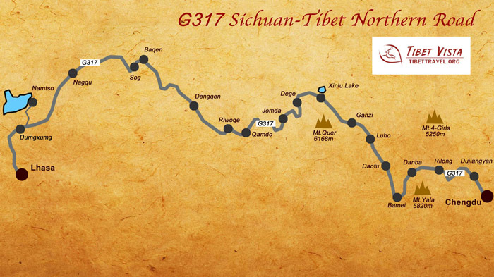 (Simple click to enlarge the map)
Sichuan Tibet Highway Northern Route Map
After leaving Xinduqiao, the road turns north to Bameizhen, at an altitude of 3,453 meters, as it crosses the edge of the Litang Grassland alongside the Yala Jokul Scenic Area. Skirting the northeastern edge of the grasslands, the route bears slightly west until it reaches Garze Monastery (3,375m). The route west from Garze Monastery is fairly level for most of the trip through Dege (3,290m) and Chamdo (3,238m), until it starts to rise again towards Nagqu, at 4,508 meters above sea level. From there it is a slow descent to Lhasa, heading through Damxung (4,200m), as the road loops round, passing Lake Namtso before turning east again and heads into Lhasa at 3,656 meters.
Chengdu to Danba - 348km of tar road
Danba to Bamei - 82km of tar road
Bamei to Garze - 243km of tar road
Garze to Dege - 205km of tar road
Dege to Chamdo - 253km of tar road
Chamdo to Lhasa - 989km of tar road
Southern Route Via China National Highway 318 (G318, 2140km)
In contrast to the Northern Route, the Southern Route runs at a slightly higher elevation after leaving Xinduqiao. The road across the Litang grasslands rises slightly to Litang, at 3,956 meters, then drops slightly, and runs at a fairly level altitude through Markam (3,871m) and Zogang (3,816m), before rising again towards Ranwu, at 3,900 meters. From Ranwu Lake, the road loops around the mountains to the north of the Dibang Wildlife Sanctuary in Arunachal Pradesh, then drops around 1,000 meters as it reaches Nyingchi, at 2,992 meters. From Nyingchi, the route runs across Shannan towards Lhasa, rising again as it lifts once more, following the Lhasa River valley to the Tibetan Capital - Lhasa.
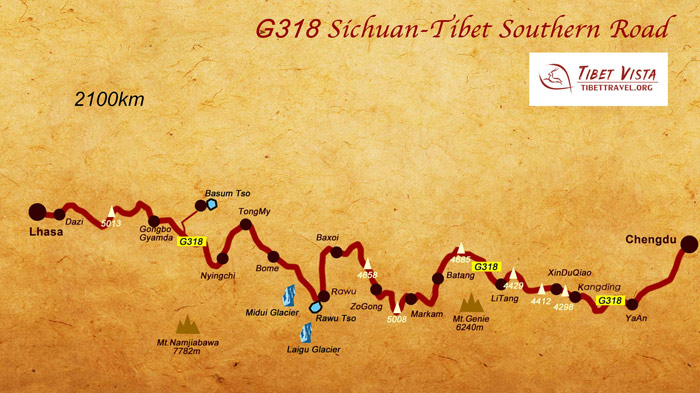 (Simple click to enlarge the map)
Sichuan Tibet Highway Southern Route Map
Chengdu to Kangding - 297km of tar road
Kangding to Xinduqiao Bridge - 71km of tar road
Xinduqiao Bridge to Litang - 205km of tar road
Litang to Markam - 276km of tar road
Markam to Zogang - 157 km of sand road and tar road
Zogang to Ranwu - 290 km of sand road and tar road
Ranwu to Nyingchi - 358 km of sand road and tar road
Nyingchi to Lhasa - 401 km of tar road
>> Read more about Altitude Change and Major Peaks along Sichuan-Tibet Highway Southern Route G318
Different Scenery and Topography
While the elevation differs only slightly, the topography of the two routes varies greatly. The Northern Route has a more level road, from Xinduqiao to Chamdo, as it traverses the high-altitude plains and grasslands, skirting the higher mountains until it reaches Chamdo. From there the topography changes as the road winds its way up and down mountains and along valleys towards the Nagqu grasslands. Then it becomes more level again, as it crosses the vast prairie and heads up to Nagqu Town. This level road continues from Nagqu, on past Namtso Lake, and along the valley floor, until it once again moves into a more mountainous landscape as it reaches Lhasa.
On the Southern Route, however, it is a very different matter, as the majority of the route traverses mountainous areas, with the road winding between the high mountains, crossing passes, and wending its way west in a snake-like pattern. With more winding turns, it is hard to see how the Northern Route is often rated as the more dangerous, and the Southern route crosses more mountainous terrain all the way from Xinduqiao to Maizhokunggar, where it turns into the Lhasa River Valley, and follows the valley floor all the way to Lhasa.
Each of the routes has its own unique scenery, with many places of interest and beauty to see along the way.
Northern Route
After leaving Chengdu, you will first come across one of the world’s most unique water conservation projects. The Dujiang Dam was built in the Qin Dynasty, and is still in perfect working order. Nearby lies the Qingcheng Mountain, with its Taoist monastery at the top. Both are now World Heritage Sites since 2000.
Further along you will see one of the top sights of this route, the Siguniang Mountain, near Xiaojin. These four mountains are all at an elevation above 5,000 meters, and house a variety of plants in this alpine climate. En route from Garze to Dege lies the beautiful Yulong La-tso, a stunning alpine lake that is backed by huge glaciers which you can walk closer to for a better view. While the walk can take a couple of hours, it is worth stopping there to see these massive, high-altitude glaciers that sit over 6,000 meters above sea level.
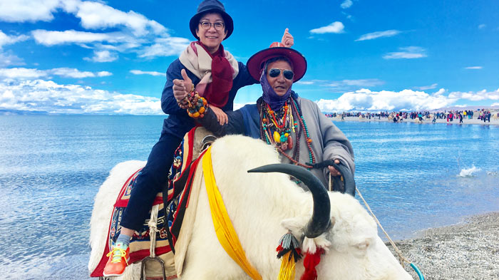 Lake Namtso
On the last stretch of the road to Lhasa lie two of the most spectacular sights in Tibet. Lake Namtso is one of the most scenic spots in Tibet, and is the largest saline lake in the region, and is one of the most beautiful places in the area. Close by are a series of caves where pilgrims have visited, and which have been hermitages for them for centuries.
And as a last side trip before reaching Lhasa, you can make a visit to Yangpachen, which is famous for its natural hot springs. The site is the highest hot springs field in the world, and the geothermal energy has been harnessed using the Yangbajing Power Station to provide electricity for Lhasa.
The northern route is sparsely populated, so do not expect to see many people and villages along the way. However, watch out for the nomads and their herds on the high prairies, especially around Lake Namtso, as these nomadic herdsmen live the same way they did centuries ago.
Southern Route
Following the southern route of the Sichuan-Tibet Highway, the first, and probably most unique site is the Mugecuo Lake. This high-altitude lake is known locally as the “savage sea”, and it is comprised of several lakes, forests, hot springs, snow peaks, and strange, standing stones. It is undoubtedly one of the most beautiful places along this route within China.
Nearby, before you leave Kangding, you can pay a visit to Hailuogou, which includes high-altitude glaciers, ice falls, and untouched virgin forests. To the west of Litang town lie the Maoya Grasslands, huge expanses of open prairie lands surrounded by high mountains. These rolling, hilly grasslands will leave you in awe of their immensity, and send you on your way to the next amazing sight with wonder.
.jpg) Hailuogou
Hailuogou
From here the road conditions get worse, and you will find you are driving up mountains on sand or dirt tracks, as you head into the alpine-forested hills of the Chamdo Prefecture. This area has been a major hub for traffic since ancient times, and has a high density population compared to most of the route. However, as you move across Chamdo, you will cross another huge expanse of grasslands, the Bangda Prairie. Here you will see many groups of nomads with their herds, grazing on the open plains.
Ranwu Lake is a hauntingly beautiful place, which incorporates high, snowy mountains with the crystal blue waters of the lake, and the lush green of the surrounding grasslands. And as you continue your journey, you will soon come across the Midui Glaciers, the most famous glaciers in southeastern Tibet. The main peak of these glaciers sits at an elevation of 6,800 meters, and is considered to be the most beautiful glacier in China.
Lulang Forest, on the road from Tongmai, is a famous scenic spot that is known for its many varieties of rare plants and trees. Instead of snowy peaks, the low mountains in this area are covered by the trees of the forest, giving the mountains a lush, green coating.
The last spots of significance before you reach Lhasa, are the waters of Nyang River and Basum Lake. The river is a major river in south-west Tibet, and is the longest tributary of the Yarlung Tsangpo River, the longest of all Tibetan rivers. Basum Lake, on the other hand, is a sacred lake for the local people, and is now an international forest park, where you can see black-headed gulls and the famous black-necked cranes of Tibet.
Once over the rough and dangerous road of Mila Mountain Pass, at an elevation of 5,000 meters, and after a good view of the whole area, it is just a short and smooth journey into Lhasa, and the end of a very long, and hazardous drive.
Different Culture Landscape
Along both routes, you can find a wealth of Tibetan culture and landscapes, and each journey is an experience of a different kind.
Northern Route
The northern route is one that is sparsely populated, which means less people, but it has a lot of temples and monasteries. There is no better way to learn about the Buddhist culture of Tibet, than to visit the monasteries and see for yourself how the people follow this unique religion. Buddhism is a major part of Tibetan culture, and it is often hard to know where the culture ends and the religion begins, since the two are so intertwined in the everyday lives of the Tibetan people.
No visit to Tibet to explore Tibetan culture would be complete without a trip to the Jiaju Villages of Danba County. These traditional Tibetan villages are the homes of Tibetans who live in the old, traditional ways, and the place is like something out of a Tibetan Fairy Tale. But the culture and traditions of their ancient Tibetan heritage live on in these villages.
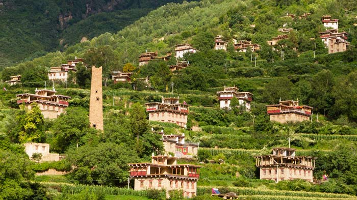 Jiaju Villages
Along the route there are several monasteries that you can visit, to learn more about Tibetan Buddhism. Huiyuan Monastery, in Bamei, was built by the seventh Dalai Lama, and is located just 8km north of the town. Unlike most monasteries in Tibet, Huiyuan is a small, low-level monastery, with simple, two-story buildings. Bamei is famous for being the birthplace of the 11th Dalai Lama, and is worth a visit to see the simplicity that some Buddhist monasteries have.
Nyitso Monastery is a 450-year-old Gelugpa monastery, and is one of the largest monasteries in the Garze region. Garze also has other monasteries, including the Garze Monastery, which was built in 1642 by Qosot Mongols, and Den Monastery, another small, simple monastery.
Larung Gar Buddhist Academy, situated in the Larung Valley, is the main center for ecumenical training in Tibetan Buddhism. The academy has been largely responsible for meeting the needs for the renewal of meditation throughout Tibet, and areas where Tibetan Buddhism is strong. It was founded in 1980, by Khenpo Juigme Phuntsok on the site of his own home. The academy has grown massively since the first group of a handful of disciples gathered together, and now houses over 40,000 residents.
Dege is an important stop if you want to learn more about Tibetan Buddhism. In the heart of Dege lies the Bakong Scripture Printing Press Monastery, which houses more than 217,000 engraved blocks, used for printing the Tibetan Buddhist scriptures, from all the Tibetan orders including Bon. This single collection makes up for over 70% of the region’s literary heritage, and includes texts on music, medicine, geography, and astronomy. The monastery is still working, and the monks there produce over 2,500 scripts per day.
Jampaling Monastery, in Chamdo County, is one of the most popular spots for tourists along the northern route, and at its height housed more than 2,500 monks. The area has an average temperature of just 7.6 degrees centigrade, and now houses some 800 monks. Take a warm jacket when you visit.
Lhasa, the end of the journey, is famous for being the most holy city in Tibet, and is the location of two of the Tibet’s most famous Buddhist sites. Jokhang Temple, in the center of the city, is considered to be the most revered temple in Tibetan Buddhism, and sees thousands of Buddhist pilgrims visiting to pray there every day. Meanwhile, the world famous Potala Palace, which was once the seat of government power in Tibet, sits atop Moburi, and looks down on the city as if granting its blessings on the people.
Southern Route
In stark contrast to the sparsely populated route to the north, the southern route is more densely populated, and there are a lot of villages and towns along the route. The southern route follows a path that is less dangerous and strenuous than the northern route, and one that travels through an area that has been heavily populated for centuries. However, the southern route has the most stunning natural scenery of the two, and is a photographer’s delight. With a much better road, traveling along this route is much easier, and less hazardous, giving you the chance to stop and get out almost anywhere to take in the beautiful, alpine scenery, and make the most of your camera.
While the route does go past many lakes and mountains, and takes in such amazing sights as the Hailuogou Glaciers and Mugecuo Lake, it also incorporates a lot of other beautiful scenery as well. At Xindu Bridge the road from Chengdu splits into the two different routes, and the scenery there is some of the most beautiful in the world. Xindu Bridge is widely known for being the best place for landscape photography, and is a snapper’s delight.
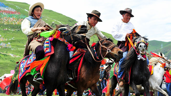 Annual Horse-racing Festival in Litang
Nearby you can see the low-lying plains of Litang, which host the annual horse-racing festival. From the 1st to 7th of August, this small town set in a long, broad valley, plays host to tens of thousands of visitors who come along to watch the races. These local Khampas, residents of what used to be the ancient region of Kham, fill the valley with their colorful tents during the festival, and makes it one that is definitely worth stopping for.
On the road to Batang you can find the largest area of natural hot springs in Sichuan. The Pucuogou Natural Ecological Reserve contains hundreds of natural hot springs, in an area known as the Chaluo geothermal area. If you are feeling achy after driving or cycling, then this is the perfect place to stop.
Once you are actually in Tibet, you will pass through Zogang County, the ancient hub for traffic in the region. The natural scenery of the river valleys is stunning, and very unique to that area, and both the Licang River and the Nujiang River cross this region. The valleys in Zogang were carved out millions of years ago by now vanished glaciers, and evidence can still be seen along the sides of the valleys in the cliff faces and hillsides.
Altogether, the scenery along the southern route is some of the most spectacular landscapes in Asia, and is well worth the long drive to see it all. And it ends with a long drive along the beautiful Lhasa River Valley, which is full of wetlands and small lakes full of wildfowl and cranes, to your destination at the capital city of Tibet.
Different History
Northern Route
The journey along the Northern Route goes through the wild, mountainous, and remote Tibetan areas of Western Sichuan, and you will be amazed to see that Tibetan culture is in many ways better preserved here than in other areas of Kham. The route offers an insight to the rich culture, costume and tradition of Khampa people and their lifestyle. Monasteries are an unavoidable part of their day-to-day life and from there you will feel their faith in religion. From Kangding to Dege, the region is populated by the ancient Khampa people, whose history is much more warrior-like than the people of the Tibet Autonomous Region. The houses are made of wood or stone, instead of the traditional concrete and mud-brick houses on the plateau. And the influence of the Han people is rarely found in the northern areas of Kham, with a very small Han Chinese presence in the region, which has long had a reputation for unruliness and independence.
Moreover, the high altitude grasslands in the northern areas are the homes of thousands of Tibetan nomads and their animals, as they graze their yaks, goats, and sheep on the lush prairie grass. The hand-made yak-wool tents of the nomads can be clearly seen from the road at many points along the highway. The journey along the Northern Route is challenging, mainly due to its geographical remoteness and poor infrastructure and facilities.
Southern Route
While the culture of the Tibetan people along the Northern route is closer to the original Tibetan culture of the days of Tibetan kings and living Buddhas, the Southern Route is flavored a little more with the influence of the Han Chinese. With a bigger population along the course of the route, which follows the old trail of the ancient Tea and Horse Caravan Road, there are more modern facilities, with a distinct Chinese character to them on the section of the road from Chengdu to Batang. Once you pass Batang Township, you are in the Tibet Autonomous Region, and again the culture changes along the route of the highway. As you move further west, the Chinese influence appears to lessen, and the traditional Tibetan culture takes hold more, with the houses changing to those of the mud-brick variety, and the traditional ways of farming and herding that can be seen all across Nyingchi.
While the G318 across western Sichuan and on to Lhasa follows the ancient Tea and Horse Road, it would appear that the route was in use long before it became an avenue for the tea and horse trade during the Tang and the Song dynasties. The route was an important connecting corridor for the ancient cultures of Tibet, Yunnan, and Sichuan, from before the influx of the Han people in the regions. Archaeological sites have been discovered that date back to around 1,600 BCE, with cist tombs that pre-date the Shang Dynasty. These tombs are mainly found in Sichuan and Yunnan, and are quite close to the old route of the Tea and Horse Road. Which means that the route has been an integral part of he history of the region for around 4,000 to 5,000 years.
Different Road Condition
As with everything else about the two routes from Chengdu to Lhasa, even the road conditions are very different. While the Northern Route is almost completely covered with a tar-based blacktop, the Southern Route has extended sections that are just sand or dirt, and often these are the parts that climb mountains and head over high passes. From Markam to Nyingchi, there are several sections of the road that are not paved, and which get bogged up whenever it gets a little wet, causing major traffic problems that can back up for miles.
The road conditions along the more-used Southern Route are also damaged by the constant running of heavy trucks, that ply the route from Sichuan to Lhasa, and beyond to Shigatse, carrying goods that, once the railway is completed, will eventually be transported by train. However, for now, the trucks keep running, and it is hard to keep the repair work up with the damage that is caused.
Another hazard that affects the road conditions along the Southern Route is the propensity for landslides. Avalanches of mud and rocks can come hurtling down from the mountains at any time, and often they cover parts of the road, leaving only one or even half a lane for vehicles to pass.
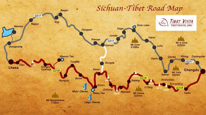 (Simple click to enlarge the map)
Sichuan Tibet Highway Map
Northern Route
For tourists driving from Sichuan to Tibet, the Northern Route is the better suited one for drivers without experience and a sense of extreme adventure. Although the road is considered more dangerous, with many sharp bends and the twists and turns up and around the mountains, a steady driver would have little problem traversing this asphalt-covered road, with its small and few sections of dirt covering.
Southern Route
On the Southern Route, However, it is a different story, With just as many switchbacks and bends as the Northern Route, it is made all the more hazardous because of the poorer road conditions along a major portion of the route. It is recommended that only very experienced drivers traverse the Southern Route, and remain attentive to the road conditions and the weather, which can make this hard drive even harder.
Different Ways to Travel from Sichuan to Tibet
Self-driving
Driving along either route can be hazardous, despite the southern route having some fairly good roads. Both routes can be subject to flash floods and mudslides in the wet, monsoon season of summer, as there is higher rainfall in southeastern Tibet than on the rest of the plateau.
Moreover, both routes are long, each more than 2,000 kilometers from start to finish, and driving such long distances can be exhausting. More so when doing it at higher altitudes. Taking regular rests along the way, and stopping overnight, is essential for safe driving. It is also a good idea to leave plenty of extra time for this road trip, as it is best to ascend to higher altitudes slowly. You may have to stop and rest for a day after making a climb to an altitude you have not experienced before.
For the northern route in particular, it is a good idea to have some experience of driving on rough, hazardous terrain. The route includes some roads that have only sand or dirt as a surface, and are normally best driven using a 4x4 vehicle. Inexperienced drivers should stick to the easier, southern route.
Finally, always check your vehicle before you start, and carry some basic spare parts for the journey. And take note of the road signs and warning signs along the way.
Cycling
Take care along the side of the highway, and always remain on the correct side of the road,keeping as close to the edge of the asphalt as is safe. Stop and wait in bad weather, as riding these roads in heavy rain or snow. Keep warm, and wear a hat to protect from sunstroke. Check your bicycle at every stop, and make sure you prepare for the next day the night before. Ride safely and do not take photos while riding. Avoid and ignore wild dogs on the route, as they will soon quiet after you pass. Panicking will make them more aggressive. Be environmentally aware, and do not throw litter on the roadside.
>> Read more about Cycling from Chengdu to Lhasa via Sichuan-Tibet Road, Tips and Details
Best Time to Travel Via Sichuan-Tibet Highway
The best time to travel along the highway, whether by bicycle or car, is in the spring or fall. Summer is the rainy season, and the monsoon rains can easily sweep you off the road, and the route is more prone to landslides at this time of year. Spring and fall have milder weather with clearer skies, which make for better viewing of the local scenery, and it is not too hot for those who are cycling.
Join-in the Most Popular Sichuan Tibet Tour
- 11 Days World-Class Overland Route: Chengdu to Lhasa via G318 National Highway
- 15 Days Chengdu Lhasa EBC via 318 National Highway Overland Tour
- 16 Days Amazing Kham Tour via G317 National Highway
- 23 Days Cycling Tour from Chengdu via Sichuan Tibet Highway
Other Tips
Make sure that you pack well for the high altitude and colder climate of Tibet, Warm clothes are a must, and will be handy even if the days are warm; the nights can still get very cold. Always carry plenty of water and snacks with you, as you may not be able to replenish in some of the longer, more remote stretches of the highway. Food can be bought at some of the towns and villages along the route, as locals have opened small hostelries to cater for the tourists along the routes. However, taking some packaged and tinned food with you is useful for when you cannot find a good place to eat. Take a small, high-altitude stove to heat water and the food, so that you are well fed along your journey.
Altitude can be a problem when traveling along the highways and you should always be aware if dramatic changes in elevation. Being prepared with a small oxygen canister is a good idea, even if you end up not using it. In addition, speak to your doctor before leaving about medications you may require as well as medicines for AMS.

Kungga Dundruk, often respectfully referred to as “Manager Kunga”, is the most revered and legendary Tibetan guide in our team.
Email me about your travel idea 18074833559


35 Comment ON "Travel from Sichuan to Tibet: Southern Route vs. Northern Route"
Asked by Liliana Me** from Macau
plan a 7-8days trip for me and my boyfriend in April
Hi! I would like to plan a 7-8days trip for me and my boyfriend in April (3rd to 10th ideally) to Nepal, Tibet, and, if possible, Bhutan. Do you think it would be doable? Based on what I read, there are some places/things to do to consider: Nepal: Everest Base Camp trek and the Annapurna Circuit, ancient temples, sacred sites like Lumbini, Kathmandu, Tibet: The Potala Palace in Lhasa and the Jokhang Temple. eventually the holy Mount Kailash or the high-altitude plains. Bhutan: Thimphu, Paro, and the famous Tiger’s Nest Monastery. To take part in cultural traditions, yoga, meditation... Of course I am open to any recommendations you could make. For your reference, we are both based in Asia: him, in Bangkok and myself in Macau. Thank you so much for the information you could provide and, if possible, an estimated budget for your offer.
Asked by Ke** from Singapore
Cycling Tour to Mt Kailash
Hi , we are planning a Cycling Trip once Tibet opens for Tourism. The plan is we shall arrive to Kathmandu , travel to the border and enter via Kerung. Can you pls send a day to day Itinerary starting from Kerung - Lake Manasarovar - Darchen - Asthapath. We shall go around Kailash on foot and resume Cycling back to Kerung. We are a Group of 6-8 persons. Thanks Pls send ur reply to Kevin
Asked by Debo** from USA
Please can you tell me the prices and dates for the Tibet Luxury Tour.
Also, could you please provide a detailed itinerary - I want to see how many hours are spent on buses/vehicles. Thank you! Deborah
Asked by S** from HongKong
Tibet Tour from HK
May I know if holding Mainland Travel Permit for HK Residents. is it also need to get the visa permit to Tibet and what is the procedure if need to apply? Thank you
Asked by Na** from USA
Is Kailash Mansarovar Trip open for Indian Passport Holder?
Is it open for Indian Passport Holder?
Asked by A** from Singapore
Enquiry on private tour
We are planning a trip from Hong Kong to Tibet during the 12th to 21st of April. We want a private tour that covers all the scenic places as well as the EBC. Please advise an itinerary along with the cost breakdown. Thanks.
Asked by Na** from Canada
We would like to take the train from Xining to Lhasa
Asked by Gr** from Canada
The "Tibet Entry Permit" should be apply
Asked by Tam** from Singapore
Sightseeing Potala Palace
Asked by Ka** from Singapore
plan to travel to Mount Kailash